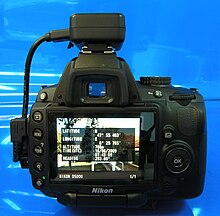
Geotagging, a digital procedure, involves the integration of geographical data into various forms of media such as pictures or videos via metadata. This location-centric information may encompass details like coordinates of latitude and longitude, or even the names of places. Its usage is widespread, especially on social media platforms like Instagram[1] and Facebook[2], where it facilitates location sharing and finding friends in close proximity. In multimedia contexts, it augments the data associated with images. The techniques utilized for geotagging differ based on the data type, with methods ranging from the use of pixel coordinates to metadata. However, this process also carries certain privacy and security risks. Despite these potential hazards, geotagging significantly enhances search result precision, enables location-based services, and aids in the organization of geographically structured data among other applications.
Geotagging, or GeoTagging, is the process of adding geographical identification metadata to various media such as a geotagged photograph or video, websites, SMS messages, QR Codes or RSS feeds and is a form of geospatial metadata. This data usually consists of latitude and longitude coordinates, though they can also include altitude, bearing, distance, accuracy data, and place names, and perhaps a time stamp.


Geotagging can help users find a wide variety of location-specific information from a device. For instance, someone can find images taken near a given location by entering latitude and longitude coordinates into a suitable image search engine. Geotagging-enabled information services can also potentially be used to find location-based news, websites, or other resources. Geotagging can tell users the location of the content of a given picture or other media or the point of view, and conversely on some media platforms show media relevant to a given location.
The geographical location data used in geotagging can, in almost every case, be derived from the global positioning system, and based on a latitude/longitude-coordinate system that presents each location on the earth from 180° west through 180° east along the Equator and 90° north through 90° south along the prime meridian.[citation needed]
The related term geocoding refers to the process of taking non-coordinate-based geographical identifiers, such as a street address, and finding associated geographic coordinates (or vice versa for reverse geocoding). Such techniques can be used together with geotagging to provide alternative search techniques.[citation needed]
