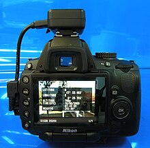
La géolocalisation, une procédure numérique, implique l'intégration de données géographiques dans diverses formes de médias tels que des images ou des vidéos par le biais de métadonnées. Ces informations centrées sur l'emplacement peuvent comprendre des détails tels que les coordonnées de latitude et de longitude, ou même les noms des lieux. Son utilisation est très répandue, en particulier sur les plateformes de médias sociaux telles que Instagram[1] et Facebook[2]où il facilite le partage de la localisation et la recherche d'amis à proximité. Dans les contextes multimédias, elle enrichit les données associées aux images. Les techniques utilisées pour la géolocalisation diffèrent selon le type de données, les méthodes allant de l'utilisation des coordonnées des pixels aux métadonnées. Toutefois, ce processus comporte également certains risques pour la vie privée et la sécurité. Malgré ces risques potentiels, la géolocalisation améliore considérablement la précision des résultats de recherche, permet d'offrir des services basés sur la localisation et facilite l'organisation de données structurées géographiquement, entre autres applications.
Géolocalisationou Géolocalisationest le processus d'ajout d'une identification géographique métadonnées à divers supports tels qu'un photographie géolocalisée ou vidéo, sites web, messages SMS, QR Codes ou RSS et constitue une forme de métadonnées géospatiales. Ces données consistent généralement en coordonnées de latitude et de longitudeBien qu'ils puissent également inclure altitude, palierLes données relatives à la distance, à la précision et aux noms de lieux, ainsi que les données relatives à l'état d'avancement des travaux, peuvent également être utilisées. horodatage.


La géolocalisation peut aider les utilisateurs à trouver une grande variété d'informations spécifiques à un lieu à partir d'un appareil. Par exemple, il est possible de trouver des images prises à proximité d'un lieu donné en saisissant les coordonnées de latitude et de longitude dans une image appropriée moteur de recherche. Les services d'information basés sur la géolocalisation peuvent également être utilisés pour trouver basé sur la localisation les actualités, les sites web ou d'autres ressources. La géolocalisation peut indiquer aux utilisateurs l'endroit où se trouve le contenu d'une image ou d'un autre média donné, ou l'endroit où se trouve le contenu d'une image ou d'un autre média. point de vueet, à l'inverse, sur certaines plateformes médiatiques, des médias pertinents pour un lieu donné.
Les données de localisation géographique utilisées dans la géolocalisation peuvent, dans presque tous les cas, être dérivées du système de positionnement globalet sur la base d'une latitude/longitude-Système de coordonnées qui présente chaque endroit de la terre de 180° ouest à 180° est le long de l'axe de la Terre. Équateur et de 90° nord à 90° sud le long du premier méridien.[citation nécessaire]
Le terme correspondant géocodage désigne le processus consistant à prendre des identifiants géographiques non basés sur des coordonnées, tels qu'une adresse de rue, et à trouver les identifiants géographiques associés. coordonnées géographiques (ou vice versa pour les géocodage inversé). Ces techniques peuvent être utilisées conjointement avec la géolocalisation pour fournir des techniques de recherche alternatives.[citation nécessaire]